BETAFor environmental, planning & engineering teams

A desktop constraint assessment in minutes, not a day.

Draw the site, run the screen, download the written report.

SiteCensus queries every layer in its library that could reach your site in one run and writes the assessment, with the reasoning and the full record behind it.

From $119 a month plus GST. Free for seven days, no card needed. Best first run: a site your team has already assessed by hand, so you can compare the two.

Beta · Queensland and New South Wales, live now · More states to follow · No install, no GIS licence

Profit for purpose. $5 of every subscription, every month, funds wildlife conservation. How it works

The platform

How it works

The data is free and official. The time goes on finding it across a dozen Commonwealth and State services, downloading it, and pulling it together into one answer by hand. SiteCensus queries it live in one workspace and writes the document that goes on file.

Step 1

Screen the site

Set the study area, choose what to check, and run one intersect across every layer whose data could reach the site. Overlaps are dissolved, so each constraint is counted once, grouped by category with its area and share of the site, and matched to the instrument it triggers.

  • ›Address, lot/plan and coordinate search, or upload SHP, GeoJSON or KML
  • ›A buffer, reported separately from the site
  • ›A constraint rating, with the rule that set it
  • ›Species with state and EPBC status, records kept apart from modelled habitat
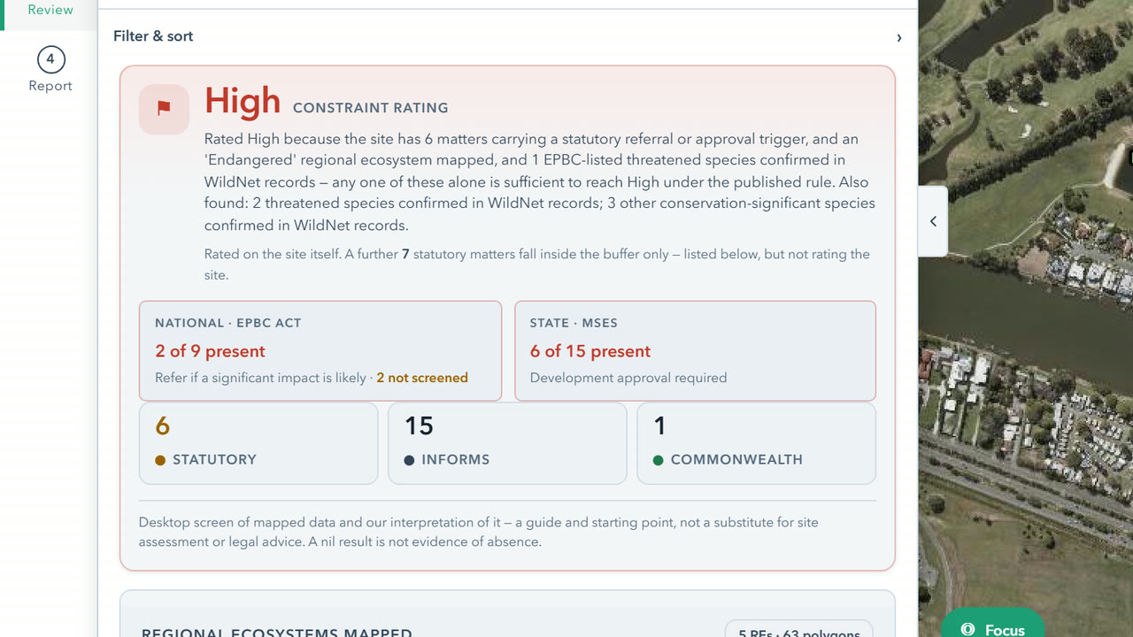
The review step at 230 Ashmore Road, Benowa: a High constraint rating with the reasons that set it, 2 of 9 EPBC matters and 6 of 15 state matters present
Step 2

Get the report

A branded report, in full or tailored through a short project intake: the constraint rating and the rule behind it, the trigger matrix, species, recommendations, limitations and the complete layer register.

  • ›Trigger matrix: legislation, pathway, agency and timeframe
  • ›Appendix A layer register, with licences
  • ›PDF and Word, and GeoJSON for each finding
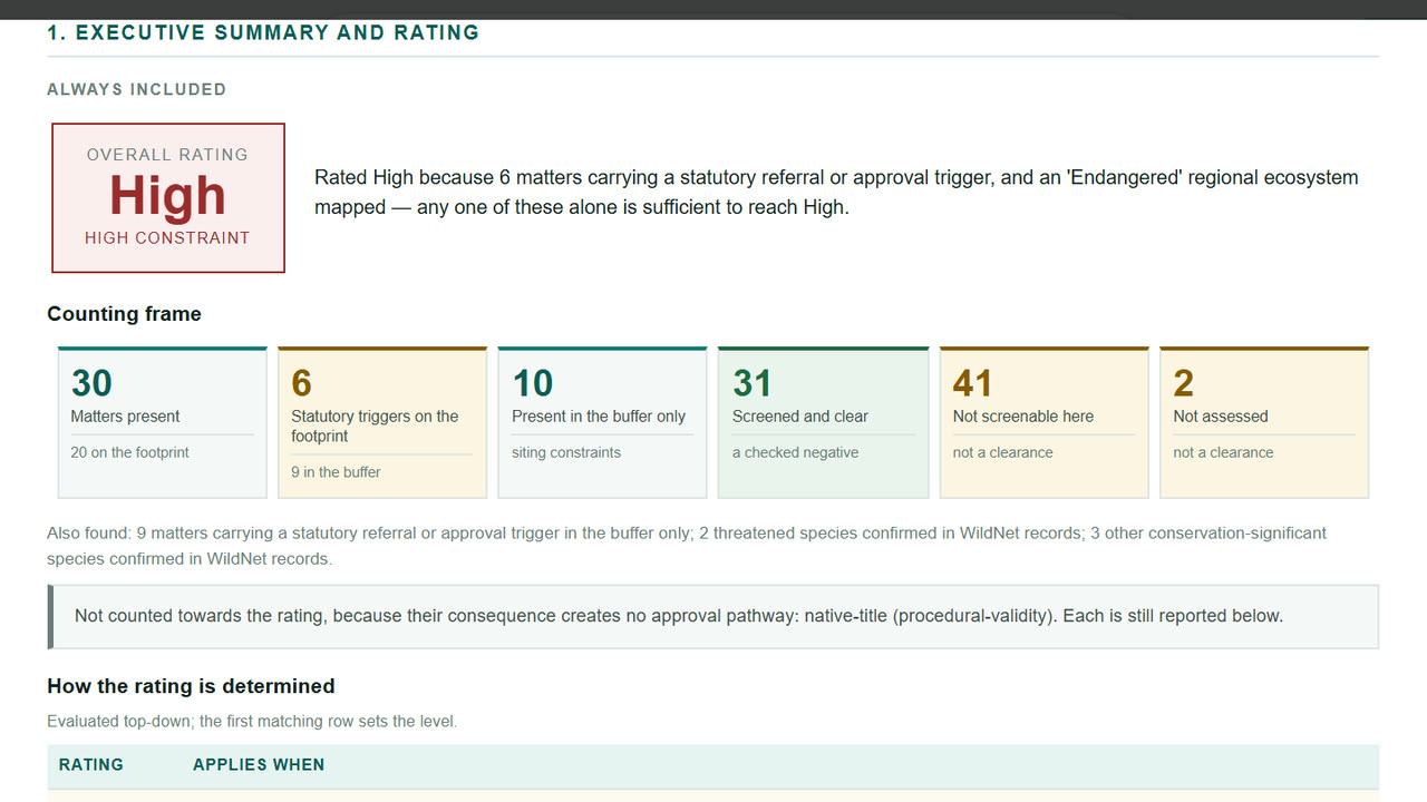
The report's executive summary: an overall rating of High, the sentence that explains it, and the counting frame of matters present, triggers, buffer-only, screened and clear, not screenable and not assessed
Step 3

Explore the map

The same data as a full web GIS, with no study area needed and nothing committed. Terrain from national elevation data, four decades of satellite record, and a print composer that produces the figure for the report instead of a screenshot.

  • ›GA 5 m LiDAR DEM with automatic SRTM fallback
  • ›Elevation, slope, hillshade and terrain profiles
  • ›Queensland aerial photography from 1930, beside today's imagery
  • ›Imagery 1988 to present, land cover, surface water
  • ›Print composer: legend, scale bar, north arrow, inset
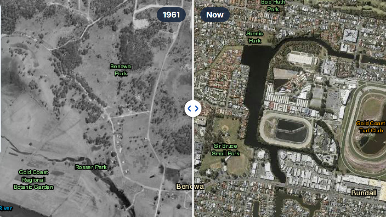
Benowa split down the middle: Queensland's 1961 aerial photograph on the left, today's imagery on the right
Method

How the assessment is produced

A screen is only useful if the output can be checked. Four things are fixed by design.

Queried live, not cached

Every layer is fetched from the custodian's REST service at the moment the assessment runs. Currency is shown per layer in the application.

Coverage is stated

A layer that fails its query is reported as failed rather than returned as zero. A service that cannot be reached is named, with its subject matter marked not covered. A run with no layers selected will not proceed.

The rating rule is fixed

Printed in the report with the matching row marked, and not adjustable from it. Modelled evidence never raises the rating on its own.

Counts reconcile

Layers queried, layers returning features, distinct constraints and total features are stated with the reasons they differ. A layer exposed twice is counted once.

Who builds it

SiteCensus is built and maintained by Dr Andrew Mackey, a geospatial and ecological scientist with 15 years in research, advisory and consulting work, including species distribution modelling at the British Antarctic Survey and constraint and opportunity mapping for state development areas in Queensland. BioGeo's consulting work is corridor connectivity, habitat suitability modelling and remote sensing. It does not offer desktop ecological assessments, DA support or field ecology, so it does not compete with SiteCensus subscribers.

National coverage

Built state by state

Each state is built against its own legislation, datasets and agencies, so they are released one at a time. Every subscription includes each new state as it launches, at no extra cost.

What's new in SiteCensus →

QLDLive
NSWLive
VICComing
WAComing
SAComing
TASComing
NTComing
ACTComing
Pricing

Two plans, every state included

All prices in AUD, GST added at checkout. Every plan includes the full platform.

Founding rate: closes 31 December 2026
Your price never rises. Solo is $119 a month instead of $149, and Team is 20% off its standard rate too (two users pay $195 instead of $244). It stays there for as long as your subscription is active, however many states are added.
Every new state is included. Queensland and New South Wales today, the rest to follow, each one added to your plan at no extra cost, at your locked rate.

Subscribe after it closes and Solo is $149 a month. The founding rate closes to new subscribers on 31 December 2026, regardless of which states have launched by then.

Founding rate · 20% off

Solo

1 user

$149$119

per month, or $1,192 a year (2 months free)

$119/month for as long as you subscribe

Seven days free, no card needed

Founding rate · 20% off

Team

2 to 15 users, priced per user

users
$529$423

per month, or $4,232 a year (2 months free)

$423/month for as long as you subscribe

Standard rate, per user per month: the first user is $149, users 2 to 5 are $95 each and users 6 to 15 are $44 each. The founding rate is 20% off that total.

5 users: $149 + 4 × $95 = $529 a month. Founding rate, 20% off: $423.

Trial: seven days, one user, no card. Seats are set up right after checkout; add or remove users later by emailing us.

Included in the price, not added to it: $5 of every month's subscription goes to wildlife conservation. BioGeo is a profit-for-purpose business. The $5 comes out of our revenue, so there is no additional cost to you and nothing to opt into. It is counted against subscriptions, so the total can be checked. How it works →

Included on every plan

  • ✓500+ live layers for Queensland, 100+ for New South Wales
  • ✓All constraint categories, plus context
  • ✓Lot/plan, address and coordinate search
  • ✓Draw boundary, upload GeoJSON / KML / SHP
  • ✓Buffer analysis, reported separately from the site
  • ✓Full or Tailored reports, via project intake
  • ✓Branded PDF & Word, with full layer register
  • ✓Print composer for branded map figures
  • ✓GeoJSON export for each finding
  • ✓Unlimited saved projects
  • ✓Email sign-in, no password to manage

Tailored terms are available for more than 15 users, for purchase orders and for government agencies. Registered charities, conservation and Landcare groups qualify for discounted pricing.

Add-on for offsets

SiteCensus Offsets: habitat quality scoring for Queensland offsets

BioCondition field data in, habitat quality scores and the Offset Delivery Plan's tables out, against every published Herbarium benchmark. A separate add-on licence, with a free single-plot calculator you can try now.

Profit for purpose

$5 of every subscription, every month, funds wildlife conservation

BioGeo is a profit-for-purpose business. Part of what you pay for SiteCensus goes to wildlife conservation every month, for as long as you subscribe. It is not a campaign and it does not end. The same pledge covers every hour of BioGeo's consulting work and every map print it sells.

Per subscription, per month

$5 from every subscription each month. It comes out of the price you pay, not on top of it.

Built by practitioners

SiteCensus grew out of the constraint screening BioGeo runs at the start of its own infrastructure and modelling work.

Tracked

Contributions are counted against subscriptions each month.

FAQ

Common questions

Anything not covered here: email info@biogeo.com.au and we'll get back to you promptly.

What does beta mean?

SiteCensus works end to end today: draw a site, run the screen and download the written report, in Queensland and New South Wales. Beta means we are still adding data, features and states, and fixing what users find, so parts of it will change. Tell us what’s missing at sitecensus@biogeo.com.au.

How does the free trial work?

Seven days on your own sites, with no card needed to start and nothing charged during the trial. Sign up with your work email and your account is ready straight away. If you subscribe at the end, billing starts then; if not, your sign-in simply stops. One trial per person.

Is this the same data as the government portals?

SiteCensus queries the same authoritative REST endpoints the agency portals use. The difference is that it runs them together against one study area and produces an assessment document. No government portal spans Commonwealth and State in a single intersect.

How many layers are queried in a run?

The library holds 500+ layers for a site in Queensland and 100+ for a site in New South Wales, Commonwealth layers included. A run queries every enabled layer whose data could reach the study area and skips only those that geographically cannot, so the number is site-specific. Each report states how many were queried and how many returned features, and Appendix A lists every one individually.

Can the reports be used in a development application?

They are suitable as supporting material in desktop assessments, EIS appendices, flora and fauna assessments and preliminary constraint reports. Results are indicative and require verification with the relevant data custodian before being relied on for statutory decisions.

Is it useful if I am not an ecologist?

Yes. The library covers ecological, abiotic, hazard, tenure and planning data. Planners, engineers and government officers use it to understand or independently verify what is on a site without producing the assessment themselves.

Does BioGeo compete with its subscribers?

No. Outside SiteCensus, BioGeo's work is geospatial science and ecological modelling: corridor connectivity, habitat suitability modelling and remote sensing. BioGeo does not offer desktop ecological assessments, DA support or field ecology.

How do I cancel?

Inside the app, open the account menu and choose Manage subscription. That opens the Stripe billing portal, where you can cancel, update your card or download invoices. Cancelling takes effect at the end of the period you have already paid for, so you keep access until then rather than losing it the moment you click.

Can I change plan or add seats later?

Not from the billing portal, which handles cancelling, cards and invoices but not plan changes. Email info@biogeo.com.au and we will move you across, including between Solo and Team or up and down the seat count.

I bought a Team plan. How do my colleagues get accounts?

Straight after paying you land on a short form: enter the name and work email of each person who needs an account, and we create them and email each person directly, usually the same day. You do not have to be one of them: if you are buying on behalf of a team, leave yourself off and give every seat away.

Lost that link? Put in the email address you paid with and we will send it again.

Get started

Run one on a site you've already assessed

Screen somewhere your team has done manually, and compare the two.